NOGGIN® GPR Systems Configuration Solutions
NOGGIN® opportunities to address your projects’ solutions
NOGGIN® Configuration Solutions


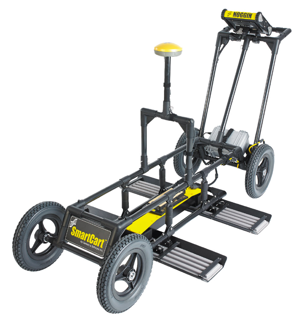
SmartCart®

SmartCart®
Mode of Operation:
The SmartCart® provides a self-contained, mobile platform for transporting the NOGGIN® and DVL for fast, efficient data acquisition over smooth to moderately rough terrain.
SmartCart® features:
A wheel odometer to trigger data acquisition at default or user-defined intervals (step size) to provide uniform data coverage. A bi-directional odometer that triggers data acquisition in one direction and, in the other direction, provides a back-up arrow to easily pinpoint the location of objects found on the survey line. Sensors & Software’s unique DynaQ® feature automatically adjusts data acquisition rates to the survey speed; providing dynamic stacking to maximize data quality.
Options:
- GPS to provide geo-referenced coordinates linked to the data
- Brackets to quickly swap between the NOGGIN® 100, 250, 500 and 1000 sensors
Supported Sensors:
The SmartCart™ supports all NOGGIN® sensors.
SmartTow™

SmartTow™
Mode of Operation:
The NOGGIN® SmartTow™ configuration is designed for hand-tow surveying over smooth to rough terrain such as grassy, brush covered or rocky surfaces. But don’t worry about damaging your NOGGIN® by dragging it around on rough surfaces – all Noggins have a durable skid plate on the bottom to smoothly slide across any surface and maintain ground-coupling for maximum signal penetration.
SmartTow™ features:
A wheel odometer to trigger data acquisition at default or user-defined intervals (step size) to provide uniform data coverage.
A bi-directional odometer that triggers data acquisition in one direction and, in the other direction, provides a back-up arrow to easily pinpoint the location of objects found on the survey line. Sensors & Software’s unique DynaQ® feature automatically adjusts data acquisition rates to the survey speed; providing dynamic stacking to maximize data quality.
Options:
- GPS to provide geo-referenced coordinates linked to the data.
- Longer cables to enable the DVL to be set in a fixed position while the GPR sensor is moved.
- Batteries of different sizes and capacities depending on field time or portability requirements
- Brackets to quickly swap between the NOGGIN® 100, 250, 500 and 1000 systems.
Supported Sensors:
The SmartTow™ supports all NOGGIN® sensors.
SmartChariot™

SmartChariot™
Mode of Operation:
The SmartChariot™ provides vehicle-towed deployment of NOGGIN® 250, 500 or 1000 systems. It is ideal for surveys covering large, smooth, open areas that can be performed using a vehicle: roads, highway sections and bridges needing quick assessment, large parking lots, parking garages, and open fields such as golf courses and parks.
The SmartChariot™ attaches to a common trailer hitch on any vehicle: cars, trucks and vans, but also ATV’s (all-terrain vehicles), tractors and even bicycles and motorcycles can be used.
SmartChariot™ features:
A wheel odometer to trigger data acquisition at default or user-defined intervals (step size) to provide uniform data coverage. Sensors & Software’s unique DynaQ® feature automatically adjusts data acquisition rates to the survey speed; providing dynamic stacking to maximize data quality.
- A mount for a GPS receiver (GPS optional).
- Brackets to quickly swap between the NOGGIN® 250, 500 and 1000 systems.
- The ability to deploy two Noggins simultaneously: a NOGGIN® 500 and a NOGGIN® 1000.
Options:
- The following optional items are available to customize the system for your needs.
- GPS to provide geo-referenced coordinates linked to the data
- Smaller or longer-life batteries depending on the time duration of measurements or portability requirements
Supported Sensors:
The SmartChariot™ supports the NOGGIN® 250, 500 or 1000 sensors.
SmartHandle™

SmartHandle™
Mode of Operation:
The NOGGIN® SmartHandle™ configuration is designed for pushing or pulling the NOGGIN® over a smooth terrain. Light and compact, the SmartHandle™ is the ideal configuration for vertical or overhead surveys, or surveys in confined spaces.
SmartHandle™ features:
A small wheel odometer to trigger data acquisition at default or user-defined intervals (step size) to provide uniform data coverage.
A bi-directional odometer that triggers data acquisition in one direction and, in the other direction, provides a back-up arrow to easily pinpoint the location of objects found on the survey line. Sensors & Software’s unique DynaQ® feature automatically adjusts data acquisition rates to the survey speed; providing dynamic stacking to maximize data quality.
A 2 piece handle that can be assembled to full length handle (0.9m, 35”) or a shorter handle (0.4m, 16”).
Options:
- GPS to provide geo-referenced coordinates linked to the data.
- Brackets to quickly swap between the NOGGIN® 500 and NOGGIN® 1000 sensors.
Supported Sensors
The SmartHandle™ supports the NOGGIN® 500 and 1000 sensors.
SmartSled

SmartSled
Mode of Operation:
The NOGGIN® SmartSled configuration is designed for vehicle-towed surveying for NOGGIN® 250, 500, and 1000 GPR systems over smooth to rough, open terrain such as agricultural fields, grass, gravel roads or rocky surfaces. The SmartSled attaches to a common trailer hitch on any vehicles such as trucks, ATVs, tractors, golf carts, or snowmobiles. Designed to deploy your NOGGIN® on various terrains, the SmartSled has built-in straps to secure the sensors and maintain ground-coupling for maximum signal penetration.
SmartSled Features
- A wheel odometer to trigger data acquisition at default or user-defined intervals (step size) to provide uniform data coverage.
- Sensors & Software’s unique DynaQ® feature automatically adjusts data acquisition rates to the survey speed; providing dynamic stacking to maximize data quality.
- Adjustable mount for a GPS receiver (GPS optional) and NIC-500N for SPIDAR.
- When coupled with an external GPS, the SmartSled can collect large GPR pseudo-grid surveys that can be processed into depth slices using the EKKO_Project software module called SliceView Lines.
- Adjustable straps to quickly swap between NOGGIN® 250, 500 and 1000 systems.
Options:
The following optional items are available to customize the system for your needs:
- GPS to provide geo-referenced coordinates linked to the data
- Varying cable lengths depending on your requirements
- Batteries of different sizes and capacities depending on field time or portability requirements
Supported Sensors:
The SmartSled supports the NOGGIN® 250, 500 or 1000 transducers.
SPIDAR® & Custom Configurations


SPIDAR® & Custom Configurations
Mode of Operation:
For applications that require large area coverage or multi-frequency concurrent data collection, two or more NOGGIN® systems can be networked together into a multi-channel GPR called a SPIDAR® system.
From towing several units behind an ATV, to deploying a NOGGIN® 1000 on a retractable arm on a mining machine, to deploying an array of Noggins on a sewer inspection platform, our custom engineering team can help you design a configuration best suited to your unique operational needs.
Options:
- SPIDAR® NICs and SpiView data acquisition software
- A wide range of ancillary handles, odometers, control system housing and cables
- Custom carts and mounting brackets
- Wireless network support for multi frequency arrays
- GPS to provide geo-referenced coordinates linked to the data
- Batteries of different sizes and capacities depending on field time or portability requirements
NOGGIN® Adaptable GPR Systems for Geophysical Surveys
TELONIX stands behind every product sold, with unmatched technical support.