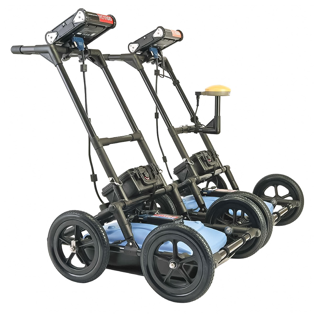
GPR – RD1100 / RD1500 Ground Penetrating Radar
Detects both conductive and non-conductive underground utilities using wide-band radar technology, internal GPS, on-board Wi-Fi and a high resolution touch screen.
GPR (Ground Penetrating Radar) systems enable operators to detect underground utilities, particularly non-conductive pipes and ducts, using high-frequency Radar. When locating underground utilities, GPR can be a valuable complement to electromagnetic cable and pipe locators.
Radiodetection’s RD1100™ and RD1500™ innovative GPR systems both use ultra-wide band 250MHz, specifically chosen for effective utility locating. Our GPR products feature internal GPS and high resolution touch screens. For connectivity and ease of reporting, both offer on-board Wi-Fi and a USB port. Additionally, the RD1500 allows users to create depth slices and review their locate path on screen while on site, and selectively enhance shallow/small, medium depth/size, or deep/large targets using the proprietary FrequenSee™ technology.
RD1100 Utility Ground Penetrating Radar
The RD1100™ Ground Penetrating Radar detects both conductive and non-conductive underground utilities using wide-band radar technology and features internal GPS, on-board Wi-Fi and a high resolution touch screen.
Radiodetection’s RD1100™ provides high-performance subsurface imaging for buried utilities in a rugged and competitively priced GPR system. Designed for the utility industry, the RD1100 features a wide-band sensor capable of detecting plastic and ceramic utilities at depths of up to 8m / 27’ deep.

Its high resolution touch screen display adds to its ease of use, including the ability to draw arrows directly on the screen to highlight subsurface features of interest.
Screenshots are taken with a single button press and saved to internal memory as JPGs. These can be exported later to a USB memory stick or emailed by connecting to a Wi-Fi network or by using a cell phone as a hotspot. Instant information, higher productivity!
GPS positioning is captured alongside the Line View data for integrating into geo-referencing packages.
Features / RD1100
Detect conductive and non-conductive pipes, ducts
Ground Penetrating Radar can detect ceramic and plastic pipes and ducts which would otherwise require tracer wire or sondes to detect using an electromagnetic locator. The RD1100’s ultra wide-band enables detection of a wide range of buried utilities without introducing the cost or complexity associated with multiple antenna GPRs.


Accurately locate and mark utilities in a single pass
To locate a feature, simply roll the system back along the same path until the red position indicator line is exactly over the response. Drag the depth indicator up or down to the desired location to display its depth value. To get the position and depth information about a different point on the screen, simply touch and hold that point for a second for a cross hair and location information to appear.
Internal Wi-Fi and USB for data transfer
Mini projects, containing screenshots and a table with information about the collected data, can be emailed immediately to clients or colleagues using the on-board Wi-Fi, either via a nearby wireless network or the user’s smart phone in hotspot mode. Screenshot images can also be exported to a USB drive for transfer to a computer or archive system.
Easy screenshot capture
One simple button press captures the Line View on screen, including GPS data and any marker arrows and flags that the user has added.


Internal GPS
The RD1100 includes GPS on board as standard, allowing screenshots to be geo-tagged and a .kmz file to be generated. This file can easily be opened in Google™ Earth, and shows you the geographic position of those screenshots.
High resolution touch screen display
The high resolution Display Unit features touch screen operation, providing the user with the ability to draw arrows on the screen to highlight features of interest. Soil calibrations are simply done by dragging a Soil Cal Hyperbola to lie over a real hyperbola from the ground and matching the shape.
Rugged yet portable
Light-weight, rugged and weatherproof (IP65) system designed for use across challenging terrain. Optional larger wheels can be fitted to ease use across particularly soft or rough ground. The RD1100 can be assembled on-site in less than two minutes, and can be dismantled without requiring tools, allowing compact storage and safe transportation. Soft and hard cases are available for transportation of the display unit; alternatively an optional flight case can be used to protect the entire system.

RD1500 Utility Ground Penetrating Radar

RD1500 Ground Penetrating Radar is Radiodetection’s flagship GPR for utility locating.
The RD1500 provides all the great features of the RD1100 and also offers Depth Slices as well as Line Views. These allow the user to review slices of the subsurface at different depths, displaying cables, pipes and other utilities in unprecedented clarity.
The RD1500 features internal GPS, on-board Wi-Fi, a high resolution touch screen as well as the proprietary FrequenSee™ technology which selectively enhances small/shallow, medium size/depth, or large/deep targets, or even all at once, for easier viewing and detection.
Mini reports can be generated and delivered directly from the survey site by connecting to a Wi-Fi network or by using a cell phone as a hotspot. Data can also be exported to a USB memory stick.
Features / RD1500 Additional Capabilities
FrequenSee™ “3 Antennas in One”
FrequenSee™ selectively enhances small/shallow, medium size/depth, or large/deep targets, or even all, for easier viewing and detection. The proprietary FrequenSee™ technology exploits the wide bandwidth of the RD1500 antenna, and allows the user to select the low, medium or high part of the frequency spectrum to focus on the desired features. Systems incorporating FrequenSee are typically lighter and less bulky that competing multi-antenna alternatives.


Software / EKKO_Project
Included within the RD1500 Enhancement option, EKKO_Project enables the user to: organise data into projects for increased storage on the RD1500; slice through the exported depth data for increased clarity generate PDF reports that include data images, screenshots and photos alongside the user’s text and company logo; and export data to other formats like CSV and SEG-Y
Enhancement upgrade option
The Enhancement option for the RD1500, which includes the EKKO_Project software suite aids in the storage, export, interpretation and presentation of the collected data by enabling the user to: organise data into projects for increased storage on the RD1500; slice through the exported depth data; generate PDF reports that include data images, screenshots and photos alongside text and your company logo and export data to other formats like CSV and SEG-Y.


Utility Suite
For RD1500 Enhancement users, the Utility Suite software option offers an even more advanced analysis solution by providing three additional modules: LineView module, which can modify the view settings to optimize the image and show data corrected for elevation; SliceView module for processing and displaying grid data as GPR lines and depth slices, and can output data into a 3D format for 3D visualization software such as Voxler® and; Interpretation module, which helps extract useful information from GPR data into other formats, such as CAD.
GPS and Map View
The RD1500 includes internal GPS as standard, enabling the unique Map View feature that allows the user to view the path travelled by the system, together with any on-screen markers made. Users looking for higher accuracy positioning data can opt for the RD1500’s external GPS, which also enables the generation of KMZ files. These files can be opened in Google™ Earth™, giving all the geographic position of where saved surveys were performed and the ability to view the screenshots that were taken.

TELONIX stands behind every product sold, with unmatched technical support.